Yachting Monthly

Distance to run made simple

David Smith is an RYA Yachtmaster and skippers for the Disabled Sailing Association. He and his wife sail a Pan Oceanic 38

There has been much said of the roles of traditional and electronic navigation techniques in recent years. For my own part I consider GPS chart plotters to be the tool to tell you where you are and where you are heading, and paper charts, along with almanacs and tidal stream atlases, are the essential tools for planning. Having spent much of my life learning navigation, not only at sea but on land and in the air, I thought I had everything needed in my navigational toolbox. However, last year I added something new.

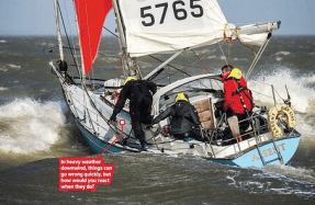
In May my wife Sarah and I began a 2,142-mile cruise from Devon to Scotland, returning in September. We sailed aboard , our Pan Oceanic 38, a cutter-rigged sloop with a pilot house and eminently suited for such a voyage. An old

You’re reading a preview, subscribe to read more.

More from Yachting Monthly

Yachting Monthly1 min read
News In Numbers
Oyster Yachts has returned to profit, showing a 29% year-on-year increase in turnover to £56.4m in 2023 OneSails GBR has recycled, re-used and repurposed over 250 old and unwanted sails in the first year of setting up its ‘ReSail’ platform. MDL Marin
Yachting Monthly2 min read
How Do I Stop My Fenders Popping Out?
Q Whilst moving into a small concrete-lined cove to be lifted out of the water, a crosswind pushed our boat against the wall and the fenders on the lee side were squished so hard that they ‘popped’ up like flying balloons. As a result, our hull was e
Yachting Monthly2 min read
A Question Of Seamanship
Q It is the roughest sea Simon has ever experienced. He and his four crew are sailing eastwards on his classic 1960s 12m wooden sloop, Sea Thrift, towards the Azores with about 500 miles to go. Fortunately it is daylight for the next few hours. Simon

Related