Some have been smart enough to examine Helicopter’s forbidding battleship prow and decline the opportunity. Too wet, too exposed, too vertical—it takes bravery to pull the pin, recalibrate and backtrack. Not many people are smart or agile enough to do this. Including me.
Fortunately, I don’t mind a clamber. So, in a painstakingly careful descent, I brought my inner frog to life. Fingers and feet suckered to barely there rock notches.
These moments of grip, kiss and hug—ie handholds doing as much as footholds to progress, intimacy with rockface to keep a backpack-encumbered centre of gravity as far away from tilt and topple as possible—are wince and worse avoidance strategies. Last time I looked, while PLBs and suchlike are great, they don’t activate themselves. A downside for the solo (ad)venturer.
There had been previous rockface confrontations, too: on the Thorn Range’s igneous metamorphosis into Crosscut Saw; and on the Viking’s rope-pull that mocked my airborne flailings as I corkscrewed my way up its renowned chimney. All three were circuit cruxes. But they were also beacons that high country bushwalking moths are compelled by.
RIVER AND RIDGE
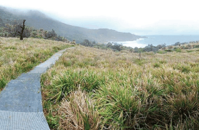
The Razor-Viking Circuit, it is claimed, takes in perhaps Victoria’s finest alpine scenery. Combining sections of formed tracks, fire trails, unmarked foot pads, and off-track bush bashing, the circuit is roughly 40km in length, and is located towards the southern taper of Victoria’s sprawling Alpine National Park, not far from Mt Buller (as the crow flies, anyway). Logistically speaking, this is only true if you opt for the non-traditional extended version I executed, and which thought about executing me.
The circuit—some of which forms part of the Australian Alps Walking Track (AAWT)—usually takes four days to complete, and commonly starts with an eastern approach drive to the Mt Howitt car park. From there, it’s a loop that passes through Macalister Springs (where the iconic Vallejo Gantner Hut grandly resides), and